
Reducing Wildfire Risk in Nepal: A Systems Approach to Protecting Ecosystems, Communities, and Infrastructure
Overview
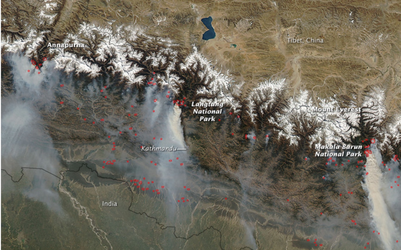
Nepal’s forests, grasslands, and wetlands are biodiversity hotspots and critical natural infrastructure that support clean air and water, agriculture, and local livelihoods. Seasonal wildfires—intensified by land-use pressures, climate variability, and resource constraints—pose rising risks to ecosystems and communities.
This case study-style insight examines why minimizing forest fires is urgent in Nepal and outlines practical, scalable solutions that combine policy, community engagement, and technology-enabled response—areas where integrated partners like Mahavir Shree International (MSIPL) can help Nepal build resilient systems.
Context and Stakes
Ecological value: Nepal hosts high endemism across the Terai, mid-hills, and highlands. Fire-induced habitat loss disrupts species ranges, regeneration cycles, and ecosystem services.
Socioeconomic dependence: Forests underpin rural livelihoods through fuelwood, fodder, non-timber forest products, and watershed protection that supports agriculture and hydropower reliability.
Public health and infrastructure: Smoke events degrade air quality, strain healthcare systems, and reduce visibility for transport. Wildfires threaten settlements, transmission corridors, telecom infrastructure, and tourism assets.
Why Minimizing Wildfires Matters
Biodiversity and ecosystem services
Repeated high-intensity fires reduce forest structure complexity, hinder natural regeneration, and fragment habitats.
Loss of pollinators and seed dispersers cascades into reduced forest productivity and resilience.
Climate impacts
Fires release stored carbon and black carbon, accelerating warming and affecting regional weather patterns.
Post-fire erosion increases sediment loads, affecting rivers, irrigation schemes, and hydropower reservoirs.
Human safety and economic disruption
Direct damage to homes, community forests, and local enterprises.
Health burdens from particulate matter; reduced visibility impacting aviation and roadway safety.
Opportunity costs: diverted public funds and reduced tourism revenue.
Root Causes and Risk Drivers
Land-use change: Agricultural burning, pasture renewal, and encroachment increase ignition sources near forest edges.
Dry season volatility: Prolonged pre-monsoon droughts and higher temperatures elevate fuel dryness.
Limited early detection and response: Sparse surveillance, delayed reporting, and constrained access slow containment.
Capacity gaps: Community Forest User Groups (CFUGs) often lack equipment, training, and integrated protocols with municipal and provincial agencies.
A Systems Approach: Prevention, Preparedness, and Rapid Response
1) Prevention and Risk Reduction
Landscape fuel management: Targeted thinning, controlled/prescribed burns under expert supervision, and green/fire breaks near settlements and critical infrastructure (roads, transmission lines, telecom towers).
Smart land-use policy: Enforce seasonal burning windows, curb high-risk slash-and-burn practices, and incentivize agroforestry buffers.
Community awareness: Fire-safe livelihood practices, safe cooking and charcoal use, and rapid reporting protocols via local ward offices.
2) Preparedness and Early Warning
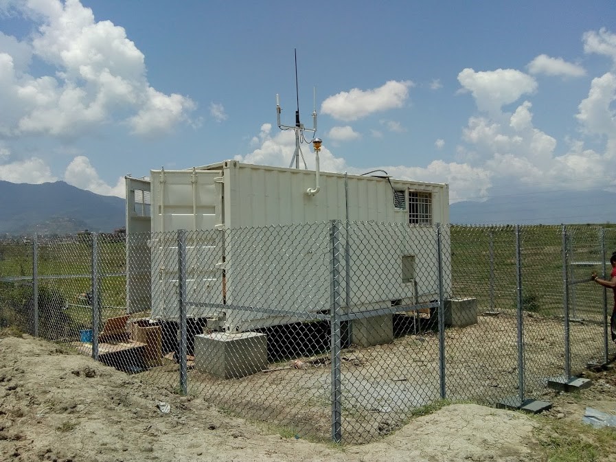
Multi-layer detection:
Satellite thermal anomaly feeds (e.g., VIIRS/MODIS) for broad-area monitoring.
Fixed optical/IR camera towers on ridgelines and along transport corridors for continuous surveillance.
Community-based lookout points linked to municipal command centers.
Risk analytics:
Fire Weather Index (FWI) dashboards combining humidity, wind, temperature, and fuel dryness to forecast daily risk.
Hazard maps integrating vegetation type, slope, settlement proximity, and access routes to prioritize patrolling and resources.
Training and drills:
Standard operating procedures (SOPs) for CFUGs, municipalities, and provincial disaster units.
Joint exercises with police, army, aviation authorities (for visibility and approach path readiness), and power utilities.
3) Rapid Response and Containment
Tiered dispatch:
Level 1: Community initial-attack teams with hand tools, bladder bags, PPE.
Level 2: Municipal/provincial units with portable pumps, slip-on tanks, and drones for hotspot mapping.
Level 3: National reinforcement with mechanized line construction, dozers for firebreaks, and air support where feasible.
Communications backbone:
Interoperable VHF/UHF networks, redundant power, and incident command radio protocols.
Mobile apps and IVR hotlines for incident reporting with geotagging and photo/video attachments.
Post-fire stabilization:
Rapid erosion control (mulching, coir logs, contour trenches) and assisted regeneration in high-value watersheds.
Illustrative Solution Architecture (Technology-Agnostic)
Sensing and data:
Satellite alert ingestion + fixed IR/optical cameras + community reports.
Environmental stations for wind, humidity, and particulate matter.
Network and command:
Secure LTE/5G and microwave backhaul to municipal/provincial Emergency Operations Centers (EOCs).
SCADA-like dashboards aggregating sensor feeds, camera streams, and GIS layers.
Analytics and visualization:
AI-assisted smoke/flame detection from camera feeds.
Risk scoring and resource recommendation engine (closest crew, access path, water sources).
Field enablement:
Rugged tablets with offline maps, turn-by-turn access routes, and dynamic perimeters.
Drone kits for thermal hotspot detection post-containment.
Maintenance and lifecycle:
Preventive maintenance schedules, spares, and training programs to ensure uptime through dry seasons.
Policy and Partnership Levers
Align with national frameworks: Integrate with Nepal’s disaster risk reduction and management policies and provincial early warning mandates.
Public–private collaboration: Utilities, airports, and road authorities co-fund monitoring along critical corridors; insurers support risk analytics to reduce loss ratios.
Community incentives: Performance-based grants for CFUGs meeting prevention and rapid reporting targets; micro-insurance for livelihood protection.
Measuring Impact
Leading indicators: Detection-to-dispatch time, containment within first operational period, percentage of fires contained under 10 hectares.
Environmental outcomes: Reduced burn area, improved air quality indices during peak months, sediment load reduction in priority catchments.
Socioeconomic outcomes: Fewer structure losses, reduced outage hours for power/telecom, improved tourism days with acceptable visibility.
How MSIPL’s Capabilities Fit
While this is an independent study and not a project reference, MSIPL’s strengths align with the solutions above:
Systems Integration: Deploy multi-sensor detection (cameras, weather stations), resilient communications, and incident command dashboards.
Contracting Services: Build towers, solar-backed power systems, and protected enclosures across rugged terrain with nationwide coverage.
Technology Distribution & Support: Provide PPE, pumps, radios, drones, and spares; deliver training, warranty, and maintenance contracts.
Cross-sector experience: Aviation visibility monitoring, power and energy infrastructure protection, and smart roadway communications adaptable to wildfire risk reduction.
Actionable Next Steps for Stakeholders
Municipalities and Provinces: Pilot a 2–3 district early detection network before the pre-monsoon season; formalize SOPs and joint drills.
CFUGs and Local NGOs: Establish volunteer initial-attack teams; implement seasonal fuel breaks around settlements and schools.
Utilities and Infrastructure Operators: Map high-risk spans and deploy camera/thermal nodes at critical points; integrate alerts into network operations centers.
Development Partners: Fund analytics platforms and capacity-building; support post-fire watershed stabilization.
Conclusion
Wildfire risk in Nepal is a solvable systems challenge. By combining smarter land management, community-driven preparedness, and integrated, technology-enabled response, Nepal can protect biodiversity, safeguard public health, and enhance the resilience of critical infrastructure. With over 30 years of experience across Nepal’s infrastructure sectors, MSIPL stands ready to collaborate with government, communities, and partners to engineer practical, scalable solutions for a safer, more sustainable future.
Sandesh Sen
Infrastructure Specialist at MSIPL
Our team of expert engineers and consultants brings decades of experience in infrastructure development, delivering innovative solutions across various industries.
Ready to Start Your Next Project?
Let's discuss how we can help you achieve your infrastructure goals. Our expert team is ready to deliver innovative solutions tailored to your specific requirements.
Related Articles
Upper-Air Radio Sounding System in Nepal
Lighting Nepal’s Gateway: Apron High-Mast Illumination at Tribhuvan International Airport